Today, I did not know how to debug the drawing in Pinggu area with the given coordinates. Finally, I found that the parameters were wrong. I didn't look at the api document carefully. It's really disgusting. Don't talk much about the code:
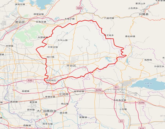
Put a picture first:
1, Coordinate conversion
        //Declare a new array
        var coordinatesPolygon = new Array();
        //Cycle traversal transfers longitude and latitude to the projection coordinate system of "EPSG:4326"
        for (var i = 0; i < coordinates.length; i++) {
            var pointTransform = ol.proj.fromLonLat([coordinates[i][0], coordinates[i][1]], "EPSG:4326");
            coordinatesPolygon.push(pointTransform);
        }
Note that if the coordinate system to be converted is not filled in after ol.proj.fromLonLat, the default value is 3857
2, All source code
        //Coordinates of Pinggu District, Beijing
        var coordinates = [[117.39680614984, 40.233089086201], [117.3600565732, 40.242113456225], [117.34874458404, 40.250260274602],
            [117.34302344712, 40.283707567814], [117.30241786584, 40.284010303013], [117.30089945595, 40.298823482743],
            [117.29495791414, 40.307241631948], [117.28090327938, 40.31483263219], [117.27787165052, 40.331469477361],
            [117.28158063671, 40.338247525913], [117.26875571365, 40.343837920124], [117.24821332321, 40.376802733207],
            [117.23311626435, 40.375365915021], [117.23011329982, 40.381697774551], [117.22184575331, 40.383995827578],
            [117.21027968492, 40.379304161599], [117.18913489167, 40.383847635371], [117.16955596667, 40.377573094897],
            [117.16201098872, 40.379609944384], [117.15156389182, 40.374358469115], [117.1461431628, 40.367421131629],
            [117.12300485064, 40.359558075585], [117.11864440401, 40.358974561797], [117.11380102691, 40.364149005012],
            [117.10453631204, 40.365747471036], [117.07808699163, 40.347405333082], [117.06520517495, 40.342543682533],
            [117.05951109694, 40.349081054111], [117.04244565157, 40.35250818155], [117.0250699279, 40.340493098635],
            [117.02117101934, 40.333168625588], [117.01588753438, 40.331656255311], [117.01173132175, 40.32337571318],
            [117.01591420209, 40.312498282132], [117.00799784424, 40.305823430052], [117.00636157925, 40.296778788538],
            [116.9970503394, 40.296137984976], [116.99575758984, 40.292616557636], [116.97796493669, 40.288167135931],
            [116.97696786259, 40.282481020224], [116.97075825127, 40.28108093448], [116.95848391237, 40.267707809995],
            [116.95715258101, 40.263327709699], [116.98168044494, 40.25377572019], [116.96338018644, 40.238052279683],
            [116.95795687613, 40.242937187356], [116.94329751003, 40.238005833847], [116.93175719996, 40.233136537486],
            [116.92430219371, 40.224967956262], [116.93485016275, 40.210980369693], [116.94526901764, 40.19855812205],
            [116.94603449564, 40.19354561168], [116.94951752277, 40.188098708124], [116.95882736017, 40.177581436424],
            [116.97897749255, 40.176575285822], [116.97881329629, 40.154560252512], [116.97587001134, 40.146838503303],
            [116.98371154588, 40.133455992809], [116.97593603278, 40.124828346814], [116.98315680573, 40.100140533332],
            [116.97155622343, 40.086210562194], [116.99084261053, 40.081393909686], [116.98663839805, 40.06927009966],
            [116.96955722573, 40.068076860016], [116.96884211824, 40.057480462171], [116.97636631342, 40.054371684127],
            [116.9795686888, 40.047516077888], [116.98518115869, 40.044388313572], [116.99304702223, 40.045029326691],
            [117.00085160401, 40.042331508548], [117.00745407085, 40.038313328591], [117.03161208113, 40.040467631252],
            [117.04575150493, 40.055833869462], [117.06992028353, 40.067915618111], [117.08846730729, 40.070826442849],
            [117.09595404341, 40.076218017715], [117.11977736834, 40.07863161916], [117.1425959885, 40.070345862074],
            [117.16234951106, 40.075084806785], [117.16799658016, 40.082010788788], [117.18330740326, 40.078432633031],
            [117.19158959317, 40.091180779552], [117.21946331827, 40.102793872514], [117.23085386426, 40.100744473507],
            [117.2308084102, 40.104832177913], [117.2565631512, 40.125816298924], [117.26463610295, 40.118734529522],
            [117.2720390385, 40.117442160668], [117.28248965384, 40.119346336362], [117.29631227787, 40.128663778615],
            [117.30298578394, 40.127129306082], [117.31838231488, 40.145192295628], [117.35175120566, 40.14858516025],
            [117.3647252165, 40.166701558473], [117.36002676882, 40.179323942797], [117.37183376251, 40.184576516774],
            [117.39959624353, 40.184618207342], [117.41343867583, 40.191765541398], [117.41039919172, 40.194936098147],
            [117.39584874998, 40.193328689781], [117.3867886771, 40.198351231932], [117.38715826407, 40.205987067737],
            [117.39482310976, 40.20909112999], [117.39525305779, 40.212222926017], [117.38556017544, 40.214479099127],
            [117.38481402713, 40.223681632946], [117.3994912696, 40.227137227499], [117.39680614984, 40.233089086201]]
        //Declare a new array
        var coordinatesPolygon = new Array();
        //Cycle traversal transfers longitude and latitude to the projection coordinate system of "EPSG:4326"
        for (var i = 0; i < coordinates.length; i++) {
            var pointTransform = ol.proj.fromLonLat([coordinates[i][0], coordinates[i][1]], "EPSG:4326");
            coordinatesPolygon.push(pointTransform);
        }
        //Tile Layer
        var tileLayer = new ol.layer.Tile({
        source:new ol.source.OSM()
        });
        var source = new ol.source.Vector();
        //Vector Layer
        var vector = new ol.layer.Vector({
            source: source,
            style: new ol.style.Style({
                fill: new ol.style.Fill({
                    color: 'rgba(255, 255, 255, 0.1)'
                }),
                stroke: new ol.style.Stroke({
                    color: 'red',
                    width: 2
                }),
                image: new ol.style.Circle({
                    radius: 10,
                    fill: new ol.style.Fill({
                        color: '#ffcc33'
                    })
                })
            })
        });
        //The polygon here must be an array of coordinates
        var plygon = new ol.geom.Polygon([coordinatesPolygon])
        //Polygon feature class
        var feature = new ol.Feature({
            geometry: plygon,
        });
        console.log(feature);
        source.addFeature(feature);
        console.log(vector.getSource().getFeatures().length);
        var view=new ol.View({
            center:[116.46,39.92],
            zoom: 10,
            projection: "EPSG:4326"
        });
        var map = new ol.Map({
            layers: [tileLayer, vector],

            view:view,
            target: "map"
        });
Three, summary
The code is simple. But if there is no language, it is also good. You don't know where to find the error. You always draw dynamically and never use the given point to draw.