Open the WRF input file, that is, the initial field file (. nc) with matlab. This paper introduces the contents of the WRF input file variables
 Times               #time
           Size:       19x1
           Dimensions: DateStrLen,Time
           Datatype:   char
——>Times: time, size 19 * 1, data type char
XLAT
           Size:       99x109x1
           Dimensions: west_east,south_north,Time
           Datatype:   single
           Attributes:
                       FieldType   = 104
                       MemoryOrder = 'XY '
                       description = 'LATITUDE, SOUTH IS NEGATIVE'
                       units       = 'degree_north'
                       stagger     = ''
                       coordinates = 'XLONG XLAT'
——>XLAT: latitude information
Size: 99 * 109 * 1
Dimension: 99 represents the East-West dimension, 109 represents the North-South dimension, and 1 represents the time dimension
Data type: single
Properties:
FieldType field type 104 (it should be the code of a certain type, which is not clear)
MemoryOrder memory order, that is, the order in which the computer CPU acquires memory. For details, please refer to https://yq.aliyun.com/articles/649307?utm_content=m_1000018012
Description: description of XLAT variable: "latitude, South is negative axis"
units: element field unit north latitude °
Stacker: stagger ed grid see https://www.openwfm.org/wiki/How_to_interpret_WRF_variables
coordinates: the correlation quantity XLAT is related to two variables XLONG and XLAT
XLONG               #longitude
           Size:       99x109x1
           Dimensions: west_east,south_north,Time
           Datatype:   single
           Attributes:
                       FieldType   = 104
                       MemoryOrder = 'XY '
                       description = 'LONGITUDE, WEST IS NEGATIVE'
                       units       = 'degree_east'
                       stagger     = ''
                       coordinates = 'XLONG XLAT'
——>Similar to XLAT, XLONG is longitude, the west is negative axis, and the numerical unit is east longitude
 LU_INDEX            #Land use type
           Size:       99x109x1
           Dimensions: west_east,south_north,Time
           Datatype:   single
           Attributes:
                       FieldType   = 104
                       MemoryOrder = 'XY '
                       description = 'LAND USE CATEGORY'
                       units       = ''
                       stagger     = ''
                       coordinates = 'XLONG XLAT XTIME'
——>Lu index: land use type
Size: 99 * 109 * 1
Dimension: East-West dimension, north-south dimension, time dimension
Data type: single precision
Correlation: XLONG, XLAT, XTIME
The official website explains as follows: https://www2.mmm.ucar.edu/wrf/users/docs/user_guide_V3/users_guide_chap3.htm#_Land_Use_and
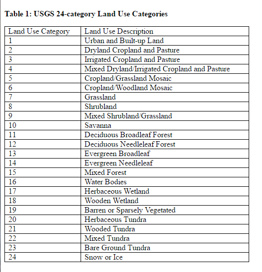
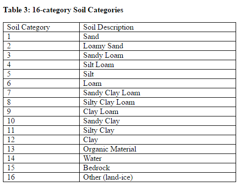
Land Use and Soil Categories in the Static Data
The default land use and soil category data sets that are provided as part of the WPS static data tar file contain categories that are matched with the USGS categories described in the VEGPARM.TBL and SOILPARM.TBL files in the WRF run directory. Descriptions of the 24 land use categories and 16 soil categories are provided in the tables below.
The WPS static data file contains data sets of land use types and soil types. There are 24 land use types and 16 soil types, as shown in the following table:
ZNU
           Size:       29x1
           Dimensions: bottom_top,Time
           Datatype:   single
           Attributes:
                       FieldType   = 104
                       MemoryOrder = 'Z  '
                       description = 'eta values on half (mass) levels'
                       units       = ''
                       stagger     = ''
->ZNU:
In the general research, we often take the altitude and the potential altitude as the stratification standard. But in the model, because the underlying surface of each area is different, some plains have plateaus, some lakes have mountains, even in a very small area, the altitude of the ground is also different, so it is very inappropriate to layer according to the potential height. So we have eta coordinates. http://bbs.06climate.com/forum.php?mod=viewthread&tid=1860&extra=&page=1
ZS
           Size:       4x1
           Dimensions: soil_layers_stag,Time
           Datatype:   single
           Attributes:
                       FieldType   = 104
                       MemoryOrder = 'Z  '
                       description = 'DEPTHS OF CENTERS OF SOIL LAYERS'
                       units       = 'm'
                       stagger     = 'Z'
——>Depth of soil Center
DZS
           Size:       4x1
           Dimensions: soil_layers_stag,Time
           Datatype:   single
           Attributes:
                       FieldType   = 104
                       MemoryOrder = 'Z  '
                       description = 'THICKNESSES OF SOIL LAYERS'
                       units       = 'm'
                       stagger     = 'Z'
——>Thickness of soil layer
 VAR_SSO
           Size:       99x109x1
           Dimensions: west_east,south_north,Time
           Datatype:   single
           Attributes:
                       FieldType   = 104
                       MemoryOrder = 'XY '
                       description = 'variance of subgrid-scale orography'
                       units       = 'm2'
                       stagger     = ''
                       coordinates = 'XLONG XLAT XTIME'
——>Var? SSO: sub grid scale topographic change
Reference paper "the influence of sub grid terrain parameterization on wind field simulation of WRF model in complex terrain area" https://www.docin.com/p-1739072234.html

 U
           Size:       100x109x29x1
           Dimensions: west_east_stag,south_north,bottom_top,Time
           Datatype:   single
           Attributes:
                       FieldType   = 104
                       MemoryOrder = 'XYZ'
                       description = 'x-wind component'
                       units       = 'm s-1'
                       stagger     = 'X'
                       coordinates = 'XLONG_U XLAT_U XTIME'
 V
           Size:       99x110x29x1
           Dimensions: west_east,south_north_stag,bottom_top,Time
           Datatype:   single
           Attributes:
                       FieldType   = 104
                       MemoryOrder = 'XYZ'
                       description = 'y-wind component'
                       units       = 'm s-1'
                       stagger     = 'Y'
                       coordinates = 'XLONG_V XLAT_V XTIME'
W
           Size:       99x109x30x1
           Dimensions: west_east,south_north,bottom_top_stag,Time
           Datatype:   single
           Attributes:
                       FieldType   = 104
                       MemoryOrder = 'XYZ'
                       description = 'z-wind component'
                       units       = 'm s-1'
                       stagger     = 'Z'
                       coordinates = 'XLONG XLAT XTIME'
——>U: Wind component in x direction
——>5: Wind component in y direction
——>W: Wind component in z direction

